Hello Investors
I must apologize for our silence on news and activities. I contracted a really nasty influenza before Xmas and still have lingering effects….it is a bad one. I am getting better but it sure set me back a bit.
Before I update you on the 2022 exploration season and then our plans for the upcoming season, I would like to discuss the overall approach CMC is taking with its property portfolio.
The property portfolio comprises of 3 properties in Newfoundland, and 5 properties in Yukon/BC. This is a large number of properties for a junior to undertake exploration and with that comes a range of challenges. But in 2022 we succeeded in advancing our knowledge and exploration efforts on seven of these properties and completed the largest drill programs ever undertaken by CMC in a singular exploration season.
Our diverse portfolio meets our objective to have a pipeline of projects that we can advance from grassroots to advanced exploration stage with the additional objective to advance a property to drill ready stage approximately every two years. This provides us with lots of flexibility in terms of future deals or initiatives that we can undertake. This may include, but not be limited to, seek project partnerships, securing our own financing and undertaking the drilling independently, and numerous other potential arrangements where we seek to maximize shareholder value. Not all properties will make the cut and of those we will divest our interests in the instance where further exploration is not warranted. For example, in 2022 we sought out a project partner for Terra Nova and divested our interest in the Rancheria South tenures. Our aim is to always have at least one, and preferably two, properties at any given time that merit undertaking advanced exploration with identified drill targets in the portfolio. We feel this serves to minimize company risk, provides us with exposure to a broader range of commodities, provides a very high level of activity with good news flow, and increases the probability for an eventual significant discovery.
We are succeeding to implement this strategy as we adopt cost effective strategies and minimize overhead costs to maximize the dollars that go into the ground. That distinguishes us from many other active junior exploration companies.
In 2019 we started out with a singular focus being the Silver Hart project. After project acquisitions in late 2020-early 2021 we have advanced Silverknife to a drill-ready stage and made significant progress to advance Amy (British Columbia) and Bridal Veil (Newfoundland) where they could be placed into a drill-ready stage within the foreseeable future.
I am more optimistic about the upcoming 2023 field season and feel it will be our most exciting one since I started with CMC in 2019.
Here is an update I have prepared from the 2022 exploration season and a brief outline of our plans for the 2023 season.
Please feel free to contact me if you have any questions or concerns.
Kevin Brewer
President and CEO
2022 Exploration Season
British Columbia/Yukon
Silver Hart/Blue Heaven
We completed 4,403.98 meters of drilling in 25 holes at Silver Hart this summer. We drilled a wider variety of targets than we had initially planned including T1, T4, the “carbonate belt” and the north end of the Main Zone veins. The drill program started late due to record snowfall levels in Yukon. Samples were submitted into labs as warranted most of which went into the lab in August and then until late September. Recently we received a lot of assays including a majority of the drill hole samples (approximately 606, with some pending), rock samples from trenching (approximately 342, with all Blue Heaven samples pending), and 65% of the soils (approximately 269 samples, with 163 samples pending).
We are now starting to process and interpret this data and expect to release the results in 2-3 weeks.
The 2022 program focussed on identifying the potential for skarn and carbonate-replacement-deposit (“CRD”) mineralization that has never been previously examined on the property. This approach, deviated from previous drilling efforts that were focussed on the high grade mineralized veins which have further potential to expand current resources. The skarn and carbonate belt rocks extend from the Silver Hart Property southeastwards onto the Blue Heaven Property which we optioned from Strategic Metals for an estimated strike length in excess of 4 kilometers. The drilling conducted this season at Silver Hart examined the portion of this belt in close proximity to the high-grade veins of the Main Zone and covered an estimated 500-meter strike length of the belt in that portion of the property.
This past year we conducted a preliminary examination of the Blue Heaven property with some trenching of previously identified showings. Over 200 rock samples were collected and assays are pending. Early field observations appear to indicate that the overall extent of these showings may be greater than previously described, although this is subjected to verification by pending assay results. There are many other showings at Blue Heaven which we need to access in 2023 and conduct detailed sampling to identify future drill targets on that property.
At Silver Hart we continue to have several areas with strong geochemical silver-lead-zinc anomalies yet to be drill tested and our current investigations have competed a preliminary evaluation of less than 15% of the carbonate belt. We also have not sufficiently tested the EM conductors which cover large areas and are challenging to effectively investigate with small drill programs. To help tackle this challenge:
- we have contracted Ronacher-McKenzie Geoscience Inc. to conduct a complete review of all CMC-related data from 2015-current. The purpose of this review is to help us better understand the nature of mineralization and to gain an independent perspective of the best approaches to undertake in the 2023 field season to pinpoint drill targets for 2024 and beyond.
- Other initial thoughts on how to pinpoint future drill targets include:
- conducting detailed gravity surveys program over the known anomalous areas, on sections of the carbonate belt, and within some of the large conductors to serve to define areas with the highest probability for precious-base metal mineralization in these areas. Gravity surveys may not be possible to conduct over many areas due to the very nature of the survey and the sensitivity of gravity meters.
- Additional geochemical (rock and soil) sampling, geological mapping, and trenching on previously identified areas of exploration interest, especially on the Blue Heaven Property.
We expect that the combination of the detailed review and additional field work will help to establish the priority and location of future drill targets.
To support its exploration programs, the Company purchased an excavator which resulted in significant cost savings in activities such as site reclamation and trenching activities. The Company conducts progressive reclamation of its sites and since 2020 has also been reclaiming and cleaning up historical work areas at Silver Hart to meet and/or exceed its commitments denoted in its reclamation and closure plan and as a part of our site security agreement with the Government of Yukon. The Company has also used local First Nations contractors to also complete these work activities and hired local workers to make ongoing improvements to its camp and related infrastructure which can accommodate up to 25 persons. The Company is committed to maximize benefits to local First Nations communities, wherever practical, possible, and feasible.
The properties collectively comprise of 4,000 hectares of land and so there is a lot of ground yet to cover. Our overall goal is to ensure that we drill test the best targets within Silver Hart/Blue Heaven over the next 2-3 years and with exploration success initiate detailed resource estimation and project economic evaluation work.
Silverknife
Silverknife comprises of 2 mineral tenures covering approximately 538.3 hectares which are immediately adjacent, and to the west of, the Silvertip mining claims owned by Coeur Mining Ltd. The Silvertip Mine is located approximately one kilometer east of the western boundary of the Silverknife property and is known to be one of the highest grade underground silver-lead-zinc deposits in the world.
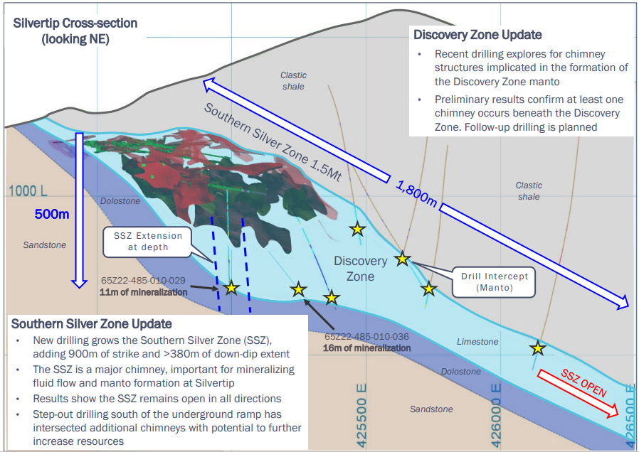
Mineralization at the Silverknife Prospect was identified through drilling in the 1980’s and is thought to represent a zone of known silver-lead-zinc mineralization distal to and is stratigraphically lower than the Silvertip Deposit. The Silverknife Prospect is also associated with proximate Cassiar Batholith intrusives that provide the very important heat source for the movement and eventual deposition of mineralizing fluids in this part of the Rancheria Silver District. Isotope studies conducted on the Silverknife prospect suggest that it is genetically linked to the Silvertip deposit. This presents opportunities for the discovery of mineralization associated with chimney-type feeders and mantos similar to those related to the SilverTip mineralizing event and that of other potential deposits now being identified in the immediate area of the mine and in close proximity to both the eastern and southern boundaries of the Silverknife property.
An example of new mineralization within the region includes the discovery of the Camp Creek West Zone by Coeur Mining Inc. (“Coeur”). This zone is located only 700 meters east of the Silverknife property boundary was noted by Coeur as to include the highest-grade silver-lead-zinc intersections yet to be identified in the area. As a result of this discovery, other newly identified extensions of the Silvertip deposit that remain open, and initial drilling efforts in other areas of Coeur’s extensive land holdings, they have committed to up to 100,000 meters of surface and 150,000 meters of underground drilling between 2023-2025. Coeur is advocating a “hub and spoke” model of CRD deposition in the region extending in a number of directions from the Silvertip deposit. This regional concept of mineralization and its possible significance has served to highlight the significant prospectivity of this area including CMC’s Silverknife and Amy Properties.
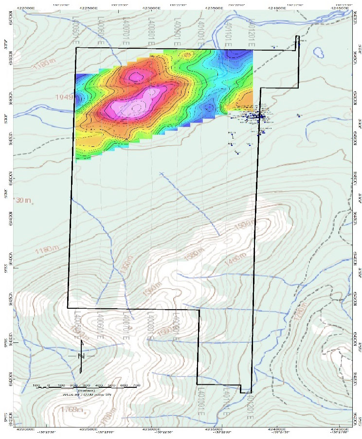
On August 10, 2022, CMC announced the highly positive results of approximately 15.4 line-kilometers of gravity survey completed in the northern part of the Property to evaluate significant conductors identified by the airborne SkyTEM survey (see CMC Press Release of July 13, 2022). Gravity surveys are designed to identify areas with higher density which provide an indication for the possibility of existence of base metals like lead and zinc which have high density. Therefore, identifying a gravity anomaly is a very good signal that base metal deposition may exist in the subsurface. In the Rancheria Silver district, silver is commonly associated with base metals.
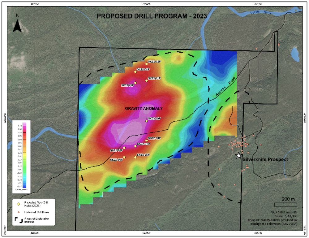
Significant gravity anomalies were found to coincide with conductivity anomalies. These targets are covered by quaternary alluvium so these geophysical anomalies were deemed new discoveries. The survey also identified a local increase in gravity in the vicinity of the historical drilling in the area of the Silverknife Prospect. Intelligent Exploration (geophysical consultants) who analyzed the gravity data, noted that the deep anomaly in the northern portion of the Silverknife Property was a good drill target and that the coincidence between the gravity and conductivity anomalies north of the Tootsee River was significant. They concluded that the gravity anomalies coincident with conductive anomalies were also in close proximity to a magnetic low and in close possible contact with the Cassiar Batholith (the “heat source” needed for the movement of mineralized fluids into the overlying sediments), which is very comparable to the setting of Coeur Mining’s Silvertip Deposit.
(Source: Intelligent Exploration, 2022)
In their presentation of December 15, 2022, Coeur Mining Inc. provided some insights possible additional prospectivity within the Silvertip region and that also relate to the Silverknife property. Some key takeaways from their presentation were as follows:
- The prospective McDame Formation (a limestone unit that is the host unit of the Silvertip deposit) extends southward into the northern part of Silverknife which is the area subject to the proposed drilling program by CMC for 2023;
- Recent exploration successes by Couer appear to demonstrate the potential for mineralization in the McDame formation is not limited to the upper section of that sequence as previously thought but also occurs throughout the unit
(Source: Coeur Mining, December 15, 2022, Presentation)
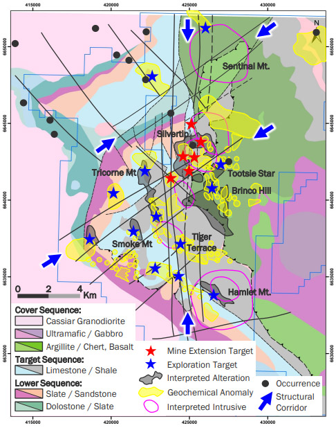
- Coeur have undertaken some regional structural interpretations which show
- A northeast trending structural corridor that aligns with the northern part of the Silverknife area in the immediate area of the gravity/conductor anomalies;
- North-south trending faults throughout the Silverknife property (Silvertip lies in close proximity to north-south trending faults); and,
- Possible intersecting fault structures in the area of the Silverknife Prospect that present possible good channels for mineralizing fluids.
- A geochemical anomaly extends southwest from the Berg Showing to the Silverknife north boundary;
(Source: Couer Mining, December 15, 2022 Presentation)
- The geological sequence covering the area of the northern portion of Silverknife appears to be a repeat sequence of the geology at Silvertip and provides support for the existence of a potential thrust fault in the area accounted by the geological unconformity. This coincides with Coeur’s regional structural analysis indicating the presence of a major northeast tending structural corridor in the northern portion of Silverknife. Areas with structural characteristics like these are often attractive areas for mineralization; and,
- Coeur have identified several intrusive centers over a 15 km strike length north and south of the Silvertip Main Zone. Intrusive centers are a key feature as carbonate replacement deposits are typically associated with intrusive bodies.
This has presented a very attractive drill target for the Company that will be pursued with a proposed initial 3,000-meter drill program during the 2023 exploration season. The permit for this drill program has recently been submitted to British Columbia for approval and the Company has also initiated engagement with affected First Nations with the eventual hope of establishing exploration agreements with their governments. It is expected that the drill permit will be received within 3-6 months.
(Source: Intelligent Exploration/Aspect North, 2022).
Amy
The Amy Property comprises of 16 mineral tenures (approximately 908.4 hectares) and is located approximately 8 kilometers to the west of the Silverknife tenures.
Amy is a highly attractive property that has been subjected to considerable historical exploration. The Amy Prospect has a historic indicated reserve of 79,849 tonnes grading 367 g/t silver, 6.0% zinc and 2.8% lead for 1,839,654 ounces at 790 g/t silver equivalent with an additional 59,000 tonnes of inferred resources with no assigned grade.
Note: CMC does not consider there to be a current resource at the Amy Prospect as details on historic estimations made are not sufficient to meet current resource reporting requirements under NI 43-101 and CIM Resource Estimation standards.
The property is currently accessed by the same road that transects Silverknife. Even though having an existing road is an attractive element for Amy, prior to reaching the property the road intersects the Tootsee River.
A brief site reconnaissance and sampling program was undertaken in 2022. Samples were taken from a couple of the historical trenches that are still on and samples were also collected from the 4200-adit dump. CRD-style mineralization is evident from the observed showings. Samples have been submitted for assay but results are still pending.
The Company has determined that another route to the Amy property should be considered to avoid this significant river crossing. A potential route is located to the north but this needs to be ground truthed and other permissions for possible construction of the route would have to be sought from other stakeholders such as Coeur who own the mineral tenures on this potential routing. This will be the focus of work on Amy in 2022.
Logjam (Yukon)
Logjam is a 100% owned property of the Company located in south-central Yukon, approximately 250 km from Whitehorse and 185 km west of Watson Lake. The property is accessible through a road extending 20 km northwards from the Yukon-Alaska Highway.
Mineralization at Logjam comprises of no less than 10 polymetallic veins containing gold, silver, lead, zinc, copper and to a lesser extent antimony, bismuth and tungsten. Logjam has seen a lot of historical work completed on the project including 701 meters of underground development in two adits (5600 and 5150 levels) and 2,971 meters of drilling. Limited exploration has taken place since the mid 1980’s but it is considered that the property has exploration potential to host a polymetallic deposit.
The Company has a permit to upgrade the road access to the property enabling vehicular traffic to the site and to conduct a range of exploration activities such as prospecting, geological mapping, geochemistry, and trenching. The Company is currently undertaking an evaluation of the Property to determine best steps forward which may include optioning the property or securing a partnership arrangement to advance exploration on the Property.
Newfoundland
Bridal Veil
The Bridal Veil Property, is a copper-silver-lead +/- gold, bismuth, and tungsten prospect located 15 kilometers east of the significant gold Queensway Project being explored by Newfound Gold Corp. Bridal Veil is adjacent to the Trans Canada Highway and comprises of 150 claims (3,150 hectares) that host six mineralized showings containing high-grade gold, copper and silver. It diversifies the Company’s holdings and significantly extends our exploration season.
In 2022, the Company completed an expansion of three of the four areas explored by geochemical soil surveys in 2021. A ground magnetometer survey of a majority of the property was completed and three additional small grids were established and sampled. Results from these field efforts are pending receipt of assays at the time of this report. The ground magnetometer survey served to define the possible contact between the intrusive and metasediments which is a potentially prospective area for mineralization. It also identified north-east trending structures which are common in other adjacent properties and on the Queensway Project and possibly are also significant in the loci and controls of mineralization in the region.
The Company is also in final stages of securing a permit to conduct a pilot Induced Polarization Survey (“IP”) which will be used to determine the effectiveness of this geophysical technique to pinpoint potential drill targets. It is expected that this 10-line kilometer IP survey will be completed in the spring of 2023. Additional geological mapping and sampling of significant areas of alteration including mineralized breccia units is also planned for 2023. The overall objective is to determine whether the project warrants drill investigation in 2024 and beyond.
Terra Nova Property, Newfoundland
The Terra Nova Property located approximately 45 kilometers southeast of Terra Nova District, Newfoundland, which property is road accessible and is transected by the HV dc power line. It is also situated approximately 32 kilometers east of the high-grade gold discovery by Newfound Gold Corp.
The Terra Nova Property comprises 71 claims (approximately 1,775 hectares) and is underlain by the Square Pond Gneiss and sedimentary rocks of the Gander Group. The Company acquired the property as prospectors had identified several high-grade copper-silver-lead showings in the area.
In 2022, the Company entered into an Option agreement with Highbank Resources Ltd. (“Highbank’) on July 4th, where Highbank earned the option to earn up to 80% ownership in Terra Nova.
Within this agreement, the Company continued as the exploration Operator. An exploration permit to construct exploration trails and conduct trenching on the known showings was acquired in late 2022. Trail construction was initiated along with a limited trenching program which was pre-empted by winter storm conditions. Plans are underway to complete the extension of the trail system to all of the property showings and conduct as more detailed trenching and pit analysis of areas over and proximal to the showings to determine both their areal extent and further define the nature of the mineralization and system controls. This work is proposed for early summer, 2023.
Rodney Pond Property, Newfoundland, Canada
The Company acquired an option to earn up to a 100% working interest in the Rodney Pond property in the highly prospective Gander Subzone in central Newfoundland, subject to an option agreement with Nancy, Stephen and Larry Rogers (the prospectors) of Hare Bay, Newfoundland.
In 2022, the Company conducted a ground magnetometer survey initially over the western part of the project and then completed a second survey over the northern portion of the Property to cover newly identified showings.
The geophysical interpretation report on this survey is pending at the time of this report. Based on the findings of this report, possible plans for further exploration of the property for 2023 will be considered.
Other Activities
On November 2, 2022, the Company commenced the development of an ESG (environmental, social and governance) manual to help develop Company policies and guide all work activities to ensure that they are being implemented in a corporate responsible manner. The initiative is designed to be the first step of a multi-phase project that is designed to ensure that the corporate philosophy and operational plans of the Company serve to mitigate and adapt project impacts on the environment, climate change, local participation, indigenous concerns and participation, local communities, project benefits, employee safety and satisfaction.
This ESG initiative is expected to evolve over the foreseeable future in particular in the area of addressing the needs and concerns of local indigenous groups and communities directly affected by our projects. In this manner it is hopeful that the outcome of these activities will serve to increase the competitiveness of our projects and de-risk both short- and long-term goals and objectives. Determining how indigenous knowledge and participation within this project is deemed fundamental to the future success of the Company.


